Early days

In 765 A.D. Scaynes Hill formed part of a scattered estate which the last South Saxon King gave to the monks of St Michael. The original charter of 765 A.D. makes some interesting references not to Scaynes Hill but to ‘Henfield’ (the old name for Scaynes Hill). These references reveal the origins of many places and place names still existing today; for example, Henfield’s Stream to Walstead and Lindfield; farms such as Bale, Novens and The Neale; Simon of Pegdon; William Nash of Nash’s Farm (who also farmed the lands belonging to the church of Lindfield); Thomas Brett (who owned 100 acres called Henfield); a furlong called Costards (Costells); Colman of Butter Box; and finally, in a letter dated 1849 from a Mr. F. Budgen, it is described how he charged for a carting stone from “Massards Farm” (now Massetts) to Scarmes Hill.
The name “Henfield” originally derived from “Heanfelde Common”. “Common” refers to the surrounding open land, “felde” to fields, and “Hean” derives from the old English “heah” meaning high. Therefore Scaynes Hill, or Henfield, was originally named quite literally as a place with high fields and open land. From “Henfield” to “Scaynes Hill” is not the only adaptation that our village name has undergone. In 1586 it was called Skerns, in 1588 Skaynes, from there Scarnes, Skermes, Skirns, Skeines, and in the collection accounts of the infamous “Window Tax” in 1747 it is described as “Scarmes Hill”.
Interestingly, from Scaynes Hill House to Hammonds Farm, down Clearwater Lane, used to be known as “Sothenbury”, this is because the ridge that starts at Scaynes Hill is the most southerly ridge before the low lying country at the foot of the Downs. Records show that a promontory fort existed here known as the “Southern Fort”, as opposed to the “Northern Fort” which existed six miles to the north at West Hoathley. At Sothenbury there was a Chapel, dedicated to St Peter, which was built about 1100 A.D. by the Third Earl de Warrenne. The site of the Chapel was probably a small plot opposite Clearwater Farm which bears the name “Chapel Plat”. Lands around Scaynes Hill House, and down Clearwater Lane, are known as Chapel Lands, and were probably the glebe (church owned) lands of the Chapel.
Centuries ago, Sussex was divided into areas called “rapes” and these were subsequently divided into “hundreds”. (A “rape” was a traditional sub-division of the county of Sussex.) Scaynes Hill is situated in the Rape of Lewes and the Hundred of Streat, and it is from this background that our local history is formed, as, in the following centuries, establishment of the grand properties of the district, and names such as Massetts, Bedales, Nash, Wapsbourne and Sennotts can be seen on old maps. The village was not of the size it is today, but was, as it still is, situated between the historical and well established settlements of Lindfield, Fletching and Chailey.
The Domesday Book is a great land survey from 1086. In the Domesday survey, Norman lords held the “rapes” into which Sussex was divided, giving their names to the divisions. There was Robert of Belleme in Arundel rape, Robert’s nephew William, Count of Mortain in Pevensey, and William de Warenne in Lewes, who was one of the very few proven “Companions” of William the Conqueror, known to have fought at the Battle of Hastings in 1066. Subsequently he became a great landowner in England.
1800/1900s

Communication, travel, ownership, and land use all affected the ways in which Scaynes Hill’s surrounding countryside was developed. Being on the Wealden Clay the village was continuously subject to the seasons of the year. Communication, both within and beyond the district, relied on tracks and roads being usable and farmers needed to be able to move and rotate livestock about at the correct times. However winter travel was regularly disturbed by the wet conditions which often prevailed. The River Ouse and the Felling Brook also had particularly strong influences on travel, and the direction of travel, as flooding in the winter would make certain routes impossible and bridges over the Ouse created key points, such as East Mascalls and Freshfield.
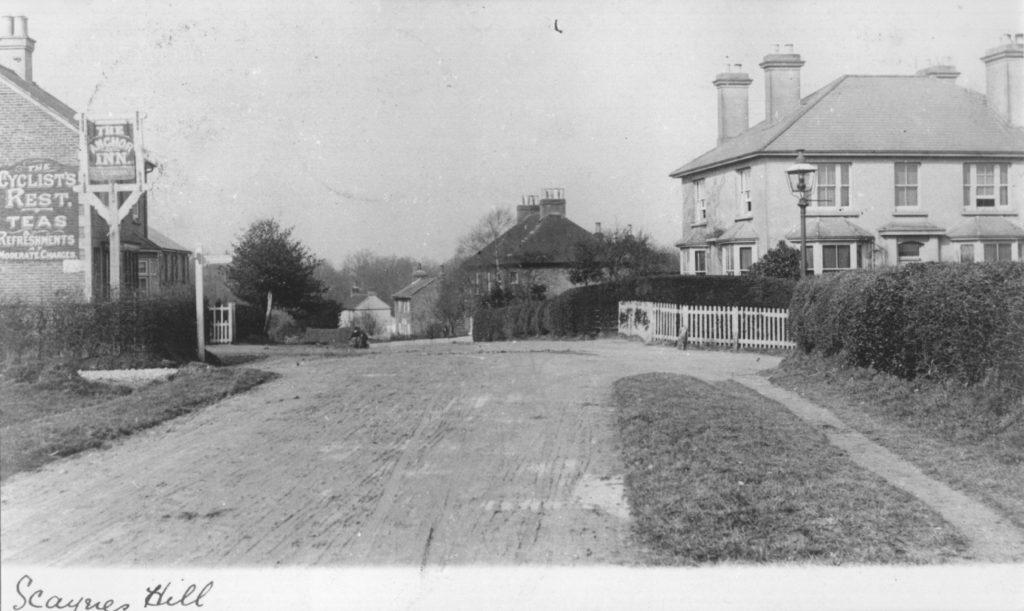
Scaynes Hill grew up in the nineteenth century around the main East/West through road, Lewes Road, with Nash Lane, Church Road and Clearwater Lane branching off it. It still had older historic areas, such as Henfield, Costells, Anchor Woods and Henfield Common and, in the outer areas, Walstead, Freshfield, Cudwells, Butterbox and Felling Bridge. It is also linked to Lindfield, being in the Rural District Parish Council. The area covered is almost 2000 hectares and the parish population in total is around 3000.
The main road through the village, the A272, now provides an important long distance route across the county, and carries much traffic. Most of the remaining older parts of the village are to the north of this road; with the noteworthy exception of the site where St Augustine’s House now stands, and where there used to be a tollgate and a small cottage.
Twentieth century and beyond

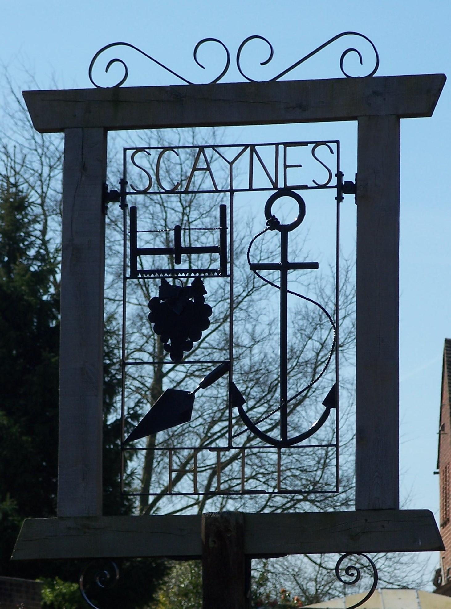
The village Sign, erected in 1977 for Queen Elizabeth’s Silver Jubilee, depicts an anchor, a builder’s trowel, a wood saw and a bunch of grapes. The Farmers pub, built in 1751, was formerly known as the ‘Anchor’ relating to the hill by which it stands, and it is thought that the term ‘Anchor’, comes not from a sea faring reference, but from the method, in days gone by, when heavy loads negotiated the hill in stages and an anchor point was put down at the top of the hill creating a fixed point to work from. The builder’s trowel signifies the old village building firm of F Dale and Co and the grapes signify the small vineyard at Rock Lodge, Anchor Hill. The wood saw represents the now defunct firm of Lewes Road Sawmills on Church Road. There was also a working village quarry, now on private land at “Inces”, Anchor Hill, last working in 1913, and stone from here was taken by road to Haywards Heath and then by train to Shoreham for use in the building of Lancing College. It is yellow sandstone of the Cuckfield Sandstone Member, and the site is notified as a SSSI (Site of Special Scientific Interest). Another area to mention is the Common, beside Church Road, a Site of Nature Conservation Importance owned by the Parish, having been purchased from the Manor of Balneath in 1996.
There used to be a butcher, a greengrocer and a Post Office on the main road, but these have all gone with only the petrol station and car showroom remaining. There are still two churches, a Strict Baptist Chapel and St Augustine’s Cof E Church, which was built in 1858. The original building on the Saint Augustine’s site was built as a school and used as a church on Sundays. In 1879 the school moved into a new building on Church Road, now “Old School House”, and Saint Augustine’s was consecrated as a full time church. The latter church separated from Lindfield Parish in 1930, becoming a full Parish in its own right. The new primary school was built in Vicarage Lane when the Costells Edge development was built, having moved from its previous site in Church Road. The Millennium Hall was built in 2000; it replaced an earlier small hall in Church Road, known as the WI Hall. There is a Village Club behind the houses in Church Road on the site of a former Reading Room. There was a wood yard on the site of the housing development “Woodcutters” in Church Road which was owned by Lewes Road Sawmills Ltd and there was a small green on the site now occupied by more modern houses at Latchetts, where there were two shops. The village, now consisting of more modern housing, is served by all the main services and has a regular hourly bus service to Uckfield and Haywards Heath.